
Open User Map
Turn your website into a living community map where visitors add and manage locations, with no coding or Google API needed.
Visit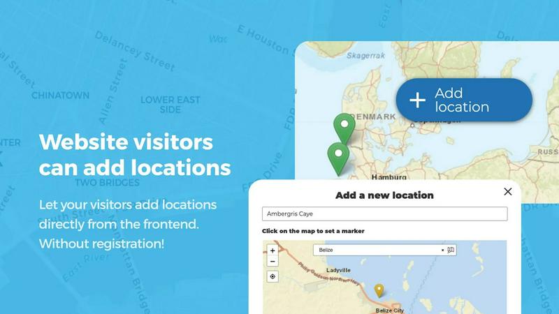
About Open User Map
Imagine a map on your website that grows and evolves not just by your own hand, but through the contributions of your visitors. This is the core promise of Open User Map, a powerful and intuitive interactive maps plugin for WordPress that transforms static geography into a living, breathing community resource. Designed for anyone from local business owners and tourism boards to real estate agents and event organizers, Open User Map allows you to create a map where visitors can add and edit locations directly from the frontend. Every submission is held in a queue, awaiting your approval, ensuring that your map remains accurate and high-quality without requiring you to do all the work. The true beauty of this tool lies in its simplicity and accessibility. It requires no coding knowledge, no expensive Google Maps API key, and no complex setup. You can have a fully functional, user-driven map live on your site in minutes. With over 15,000 active installs and a perfect 5-star rating on WordPress.org, Open User Map has proven itself as the go-to solution for creating collaborative maps. Whether you want to build a directory of local hotspots, map out a festival grounds, or create an interactive campus guide, this plugin provides the foundation for a journey of shared discovery between you and your audience.
Features of Open User Map
Frontend Location Submissions and Editing
This feature is the heart of the collaborative experience. It allows your website visitors to directly add new locations to your map by clicking an "Add location" button. A simple form pops up, guiding them to place a marker on the map and fill in the details. Crucially, these submissions do not go live immediately. They enter an approval workflow, giving you complete control over what appears on your map. Furthermore, users can return to edit their own existing locations, ensuring that information like business hours or contact details stays current. This turns your map from a static snapshot into a dynamic, community-maintained resource.
Effortless Categorization and Filtering
Bring order to your map by grouping locations into distinct marker categories, each with its own unique icon. This visual organization helps visitors quickly understand the landscape of your map at a glance. More importantly, it empowers them to filter the map to see only what interests them. For example, a city guide map could have categories for "Restaurants," "Parks," and "Museums," allowing a user to view only the restaurants. The flexibility is enhanced by the ability to assign a single location to multiple categories, ensuring that a "Cafe" with "Free Wi-Fi" is found under both relevant filters.
Lines and Areas
Go beyond simple point markers with this feature that allows you to draw routes, paths, zones, and regions directly on your map. This is perfect for highlighting hiking trails, defining service areas for a delivery business, outlining event grounds, or marking construction zones. The tool automatically calculates the distances and area sizes, so your routes and polygons come with helpful measurements built-in. This adds a powerful new dimension to your map, allowing you to communicate complex spatial information at a glance, making it invaluable for guides, logistics, and planning.
Custom Image as Map
This innovative feature breaks the traditional mold by allowing you to upload any image and transform it into a fully interactive map. Instead of a geographic map, your canvas could be a floor plan, an event layout, a seating chart, a product diagram, or a campus guide. Visitors can then place markers on this custom image with the same powerful functionality as a standard map. They can add locations, fill out custom fields, and use filters to explore the image-based map. This opens up a world of possibilities for creating engaging, clickable experiences tailored to very specific, non-geographic needs.
Use Cases of Open User Map
Building a Community-Driven Local Business Directory
A local tourism board or city guide website can use Open User Map to create a vibrant directory of the best local spots. Visitors can submit their favorite new coffee shop, a hidden park, or a boutique store. The approval workflow ensures quality control, while the categorization and filtering features allow users to easily find exactly what they need, from "Pet-Friendly Cafes" to "Live Music Venues." The upvote and star rating features then help the community itself highlight the most beloved locations.
Mapping an Event or Festival Grounds
For event organizers, Open User Map is an essential tool for attendee experience. They can upload a site map as a "Custom Image" and allow vendors to submit their location. The map can show food trucks, stages, restrooms, first aid stations, and merchandise booths. Attendees can use the map to navigate the grounds, find specific vendors, and even see real-time information. The "Lines and Areas" feature can be used to highlight parade routes or designated seating zones, making the event easier and more enjoyable for everyone.
Creating an Interactive Real Estate Portfolio
A real estate agent can use Open User Map to build a powerful, interactive portfolio for their clients. They can place markers for each property listing, using custom fields to include details like price, number of bedrooms, and square footage. The "Regions" feature can be used to define different neighborhoods, allowing clients to filter properties by their preferred area. By enabling visitor submissions, the agent could even allow homeowners to express interest in selling, turning the map into a lead generation tool.
Developing a Campus or Office Wayfinding Guide
Universities and large corporations can deploy Open User Map to help people navigate their sprawling campuses. The map can show all key buildings, from lecture halls and libraries to cafeterias and parking lots. Using "Lines and Areas," you can map out walking paths, shuttle routes, and designated smoking zones. The "Custom Image as Map" feature can be used for individual building floor plans, showing the location of specific offices, labs, or classrooms. This creates an all-in-one navigation solution that is far more intuitive than a static PDF.
Frequently Asked Questions
Do I need a Google Maps API key to use Open User Map?
No, you do not. One of the core value propositions of Open User Map is that it works without requiring a Google Maps API key. This saves you the complexity of setting up billing and managing API quotas, allowing for a much simpler and more cost-effective setup process.
Can visitors add locations to the map from the frontend of my website?
Yes, absolutely. This is a primary feature of the plugin. Visitors can click an "Add location" button on your map, place a marker, and submit details through a form. These submissions are then held in a moderation queue for your approval before they are published on the map, giving you full control over the content.
What kind of custom data can I collect from user submissions?
Open User Map offers flexible custom fields to tailor your data collection. You can add text boxes, links, checkboxes, and dropdown menus to your submission forms. This allows you to gather exactly the information you need, such as a location's website, phone number, or specific attributes like "Has Parking" or "Wheelchair Accessible."
Is there a way for the community to rate or highlight locations?
Yes, Open User Map includes community engagement features. You can enable "Upvotes & Likes" so visitors can vote for their favorite locations, helping to highlight the best places or flag inappropriate content. Additionally, you can enable a full 1-5 star rating system, allowing your community to provide more nuanced feedback and automatically promote top-rated spots.
Similar to Open User Map

Built2Win AI Indexing
Custom PHP websites, AI Indexing Pack ($599 one‑time), and WebAgentScan SaaS ($9/mo). MCP, A2A, llms.txt, full ownership.

Techlusion
Techlusion builds scalable software and cloud solutions that help modern businesses innovate, automate, and grow with confidence.
Webleadr
Webleadr guides you to instantly find and contact local businesses without websites, turning them into your next web design clients.

Idearium
Idearium crafts unforgettable websites and digital experiences that elevate your brand and drive meaningful growth.

FilexHost
Effortlessly host and share your files with FilexHost, generating shareable links in seconds using simple drag-and-drop.

Crawlkit
Turn any website into a structured API with a single, simple call.
Best Boilerplates
Unlock your SaaS potential with Best Boilerplates, your gateway to finding the ideal starter kit for rapid app.

Shadcn UI Kit
Begin your next project with ready-made components that turn your vision into a working application faster.