GeoRank
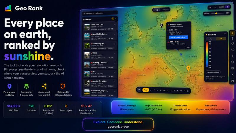
GeoRank turns your relocation research into a journey, letting you explore, compare, and ask AI about any place on earth.
VisitPublished on:
July 13, 2026
Pricing:
About GeoRank
GeoRank is a free, no-signup interactive map designed to end the chaotic, multi-tab research process of deciding where to relocate or spend an extended stay abroad. Instead of juggling a weather site, Numbeo, embassy pages, and nomad forums that never talk to each other, GeoRank layers eight comprehensive data sets over a global grid with approximately 5-kilometer resolution. This tool is built for digital nomads, expats, remote workers, and anyone contemplating a major life move who needs a single, grounded decision-making platform. Its main value proposition is replacing scattered research with one unified experience: you can explore the world through calibrated data on sunshine, temperature, rainfall, taxes, visa routes, cost of living, geopolitical risk, and community sentiment. You can pin your candidate places, compare every metric as a delta against your current home, and even ask an integrated AI assistant that reasons exclusively over your own shortlist. GeoRank transforms abstract browsing into a concrete, comparative, and deeply personal journey toward your next home.
Features of GeoRank
9 Live Map Layers
GeoRank offers nine distinct, toggleable data layers that you can stack and explore in real time. These include sunshine, temperature, rainfall, outdoor hours, taxes, visas and residency, cost of living, geopolitical risk, and a community-sourced "Nomad Pulse" sentiment signal. Each layer is powered by authoritative sources such as SARAH-3 satellite data, ERA5 reanalysis, OECD tax databases, and PwC summaries, giving you a rich, multi-dimensional view of any location on earth.
Pin and Compare Mode
You can click any location on the map to pin it, saving up to 20 places across sessions. Once you set your current home as a baseline, switching to Compare mode transforms every metric into a meaningful delta. You instantly see how much warmer, cheaper, safer, or differently taxed a candidate city is compared to where you live now, turning absolute numbers into a personal, relatable story about your potential move.
AI Assistant for Your Shortlist
The integrated AI chat operates exclusively on your pinned locations, not a generic knowledge base. You can ask questions like "Which of my 5 places has the best winter?" or "Score my shortlist for sunshine, cost, and low tax combined." The AI reasons across all your specific data points and delivers grounded, cited answers that help you weigh tradeoffs without leaving the tool.
Calibrated Data Accuracy
Unlike raw satellite data that can overestimate sunshine in cloudy regions, GeoRank merges SARAH-3 satellite observations with ERA5 and CHELSA data, bias-corrected against 182 ground stations worldwide. This calibration includes orographic terrain corrections, ensuring accuracy from Reykjavik to Phoenix to Sydney. High-altitude and coastal microclimates are noted with specific error margins, so you trust the numbers you are comparing.
Use Cases of GeoRank
Finding a Winter Sun Base
A remote worker on a UK passport wants to escape the British winter. They pin five candidate cities in Southern Europe and the Canary Islands, set their home as London, and use the AI to ask, "Which of my pinned places has the best winter sunshine and is cheapest?" GeoRank instantly compares sunshine hours, cost of living, and visa-free stay duration, delivering a clear winner with cited sources.
Comparing Tax Regimes for Freelancers
A freelance designer considering a move to either Tbilisi or Paphos uses GeoRank to compare income tax rates, visa rules, and cost of living. By setting their home baseline and using Compare mode, they see that Paphos offers more sunshine but higher monthly costs, while Tbilisi has a zero percent tax on foreign-sourced income. The AI then answers specific tradeoff questions, helping them decide based on their priorities.
Family Relocation Assessment
A family with a Canadian passport is evaluating Lisbon, Valencia, and Kuala Lumpur for a one-year stay. They use GeoRank to overlay geopolitical risk, outdoor hours, and cost of living layers. They pin all three cities, set their home, and ask the AI to rank them for safety, family-friendly infrastructure, and school access. The tool provides a comparative analysis that no single website could offer.
Digital Nomad Sentiment Tracking
A seasoned nomad wants to find emerging hotspots before they become crowded. They use the Nomad Pulse layer to see where community sentiment is rising, falling, or stable. By combining this with sunshine and cost-of-living data, they identify a city in Southeast Asia that is gaining buzz but remains affordable, allowing them to make a proactive move based on real-time community signals.
Frequently Asked Questions
Do I need to create an account to use GeoRank?
No, GeoRank is completely free and requires no signup or account creation. You can open the map, explore all layers, pin locations, and use the Compare mode immediately without any registration. Your pinned places are saved across sessions automatically using local storage in your browser.
What data sources power the map layers?
GeoRank uses a combination of high-quality, authoritative data sources. Sunshine data comes from SARAH-3 satellite observations and ERA5 reanalysis, calibrated against 182 ground stations. Tax rates are sourced from OECD, PwC, and KPMG databases. Cost of living data is drawn from 478 cities, while visa and residency information covers 47 destinations for 10 different passports. Geopolitical risk and Nomad Pulse sentiment are also integrated.
How accurate is the sunshine and temperature data?
The data is calibrated for high accuracy. Sunshine data has an accuracy of plus or minus 8 percent for most locations, though high-altitude areas may be plus or minus 15 percent and coastal microclimates plus or minus 20 percent. Temperature data uses a similar calibration process against ground stations, ensuring that the numbers you compare are grounded in real-world observations rather than raw satellite estimates.
Can the AI assistant answer questions about any city in the world?
The AI assistant is designed to reason only over your pinned shortlist of up to 20 locations. It does not have access to a generic knowledge base about every city. This ensures that its answers are directly relevant to your specific candidate places and the data GeoRank has compiled for them, providing grounded, cited responses that are tailored to your decision-making process.
Similar to GeoRank

Orlyn
Privacy-first, cookieless web analytics that ties your traffic and marketing channels to real Stripe revenue.

Hotel Lobby AI Video Generator
Turn two photos into a Hotel Lobby dance video in the orange A COLORS SHOW booth
tallycounterweb.com
Online tally counter for tracking attendance, workouts, inventory, visitors, sports scores, habits, and everyday counting tasks.



AI UGC Video Generator
Create AI UGC video ads from a product URL, image, or script with lifelike creators, natural voices, captions, and clear CTAs.